Geology
Definitions and images to illustrate geological terms, links to images and website articles
Navigation
- directions
- ▪ Earth Sciences
- ▪ A
- ▪ accretionary prism
- ▪ anatexis
- ▪ anticline
- ▪ argillic
- ▪ assimilation
- ▪ B
- ▪ back-arc forearc
- ▪ Baltica
- Rocks & Minerals: Alphabetic Sections ◊ A ◊ B ◊ C ◊ D ◊ E ◊ F ◊ G ◊ H ◊ I ◊ J ◊ K ◊ L ◊ M ◊ N ◊ O ◊ P ◊ Q ◊ R ◊ S ◊ T ◊ U ◊ V ◊ W ◊ X ◊ Y ◊ Z ◊ elements of periodic table ◊ Mineral Index ◙◙ Rock Index: alphabetic ◙◙ Rock Index: Igneous Rocks ◙◙ Rock Index: Metamorphic Rocks ◙◙ Rock Index: Sedimentary Rocks ◙◙
- Abiogenesis & Evolution
- Algorithms of Evolution
- Cancer
- Cell Biology
- Chemistry of Life
- Cyanobacteria
- Enzymes
- Evo Devo
- Fat
- Immunology
- Mechanisms of Evolution
- Molecular Biology
- Origin of Life
- Paleogeology
- Proteins
- Receptor
- Refuting ID
- Serial Endosymbiosis
- Signaling
- Sleep
- Stem & Progenitor
- Stromatolites
- Taxonomy Phylogeny
- Tissue
- Virus
- Endosymbiosis
- Organics
- Galaria
Items
![]()


Companion Sites
Gray Sites
White Sites
Black Sites
Miscellaneous
Search
Site Maps: Gray Companion Sites:


gabbro
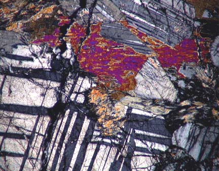
 Gabbro is a coarse-grained, plutonic igneous rock that forms at spreading centers in rift zones and mid-ocean ridges (so underlies oceanic crust). Gabbros can form as massive uniform intrusions or as layered ultramafic intrusions formed by settling of pyroxenes and plagioclase (pyroxene-plagioclase cumulate).
As an essential component of the oceanic crust, gabbros are found in many ophiolite complexes in the sheeted dyke zone to massive gabbro zone (zones III and IV). Long belts of gabbroic intrusions are typical at proto-rift zones and around ancient rift zone margins, where they intrude into the rift flanks.
Gabbro is a dense rock that is greenish or dark-colored and comprises varied percentages of pyroxenes, plagioclase, amphiboles, and olivine. Where olivine is present in large quantities, the rock is termed olivine gabbro.
A finer grained rocks with the same composition as gabbro is termed diabase.
[images : layered gabbro, North Cascades : Salem gabbro-diorite cut by a a composite dike with felsic margins and a central core of basaltic rock : White Mountain Magma Series : pegmatitic gabbro : oceanic crust exposed on Cyprus : oceanic crust gabbro, 2 : thin section Oman Ophiolite gabbro : thin section of olivine gabbro - pyroxene and olivine show bright colours, striped grey rectangular crystals are plagioclase feldspar : thin section of gabbro with plagioclase and hypersthene (orthopyroxene) : hypersthene gabbro : thin section with pyroxene and (striped) plagioclases : thin section orthopyroxenes crystals surrounded by alteration (uralite) : thin section : thin section with twinned plagioclases ]
Labels: gabbro, mid-ocean ridges, olivine, ophiolite complexes, spreading centers
geological maps
A geological map provides a graphic representation of selected geological features within a desired surface topographic or subsurface area. The size and relative position of each feature on the map corresponds to its correct geographic situation according to an established scale and projection. Mapped features included in the map key include geologic units, stratigraphic contour lines, fault lines, strike and dip lines, and other symbols. Information can be extrapolated from surface mapping in order to postulate the distribution of geological features in the subsurface. Resulting hypothetical structural models can provide the basis for exploring the landmass in search of its resources.
Commonly, geological features cannot be measured continuously over large areas, so other forms of evidence are employed to infer the delineation of large or hidden features. Surface geological features may be traceable in bedrock outcroppings (ground surveys), from air photographs (photogeological reconnaissance) and/or from satellite images. Subsurface geological features may be traceable in boreholes using cores, cuttings and/or geophysical logs. Geophysical surveys (measuring the magnetic, gravitational, or seismic properties) provide information that helps delineate geological features in the subsurface.
A Geographic Information System (GIS) is an efficient way to manage, analyse and display spatial data. Data from a variety of different sources can be rapidly computer-overlaid for viewing and analysis.
[links: images: LANDSAT image gallery, Geology - Oman; Seafloor Mapping, Bahia, Brazil; websites: Geological Map of Canada : Structural Geology (animations) : Geologic Maps from USGS National Park Service : Geological Maps, UWisc : USGS National Geologic Map Database : USGS Geology in the Parks : Animations : Plate Tectonics : Rocks & Minerals : Geologic Time : Glossary : Geomorphic Provinces : Sand Dunes : Caves : Glaciers : Coasts : NPS Park Geology Tour home]
Labels: dip, fault lines, geological maps, geological structures, magnetic, map key, seismic, stratigraphic units, strike, symbols, topographical
Gondwana
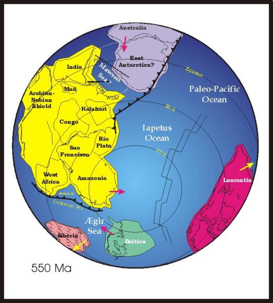 Gondwana, or Gondwanaland (yellow at left) was a supercontinent that assembled (animation) during the late Precambrian-early Cambrian (550-500 Ma).
Gondwana, with East Antarctica as its center, began to break up during Late Triassic to Early Jurassic time (182 Ma to 64 Ma) : A Tight fit-Early Mesozoic Gondwana: A Plate Reconstruction Perspective : pdf.
Labels: Cambrian, Gondwana, Gondwanaland, Precambrian
| 0 Guide-Glossarygranite
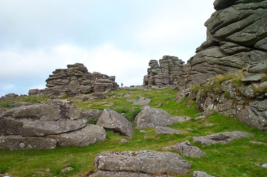
 Granite is typically a medium to coarse grained felsic, intrusive igneous rock (plutonic) that is usually pink to dark gray, sometimes black, depending on its chemistry and mineralogy. Granites are the commonest basement rocks of the continental crust, many dating from the Precambrian.
In some granites, individual crystals are larger than the groundmass (porphyrys). Granites primarily comprises orthoclase and plagioclase feldspars, quartz, hornblende, muscovite and/or biotite micas, with minor accessory minerals such as magnetite, garnet, zircon and apatite. Rarely, a pyroxene is present. Very rarely, iron-rich olivine, fayalite, occurs.
Granites are classified according to the QAPF diagram for granitoids and phaneritic foidolites (plutonic rocks) that compares the percentages of quartz, alkali feldspar (orthoclase, sanidine, or microcline) and plagioclase feldspar.
As a plutonic rock, granite is often exposed in weathered tors, dykes and as massive batholiths.
Labels: felsic, foidolite, Granite, granitoids, igneous, intrusive, phaneritic, plutonic, QAPF diagram
| 0 Guide-Glossarygreenstone belts
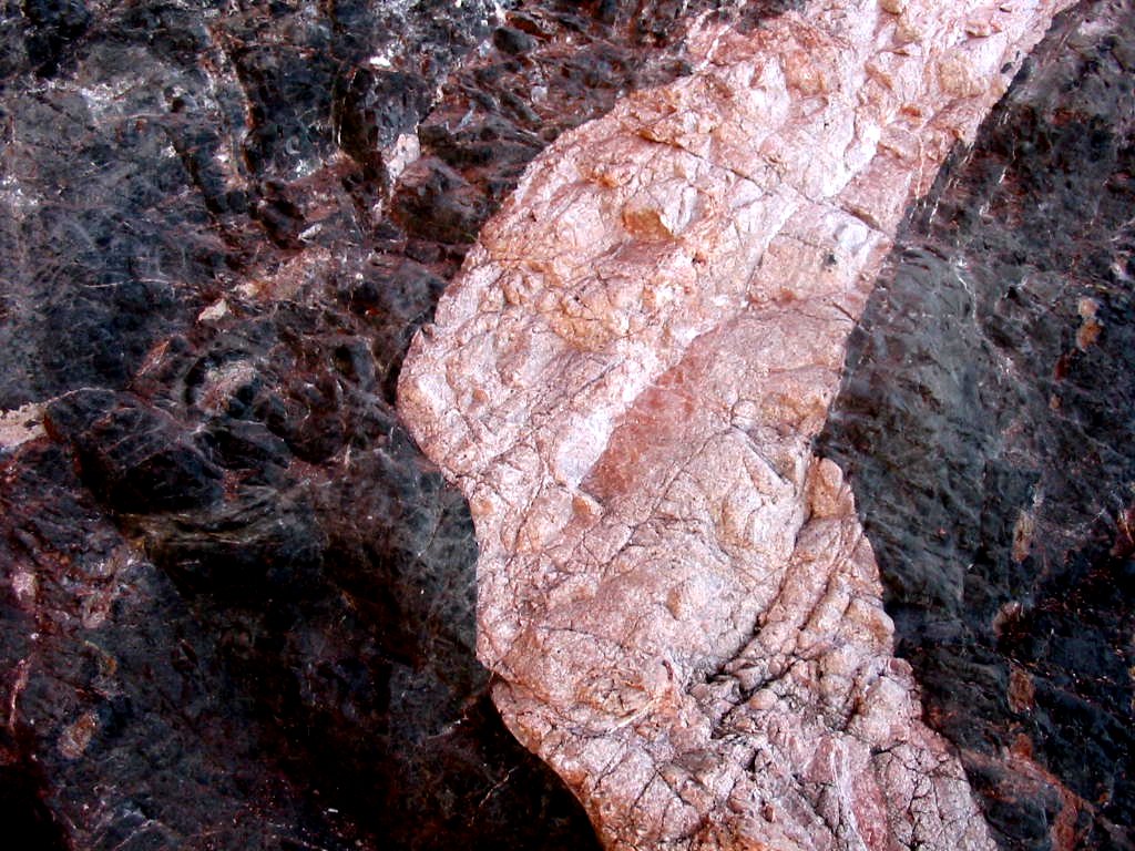
 Greenstone belts are zones named for the green hue imparted by chlorite (left) minerals within the rocks, which are variably metamorphosed (greenschist) mafic to ultramafic volcanic sequences associated with sedimentary rocks. Greenstone belts are found between granite and gneiss bodies in Archaean and Proterozoic cratons.
Greenstone belts are interpreted as having formed at ancient oceanic spreading centers and island arc terranes.
◙ greenstone-hosted quartz-carbonate vein deposits ◙ GQCV
Shield greenstones are located in:
● Slave craton of Canada (Archaean and Proterozoic)
● Pilbara craton of Australia (Archaean)
● Barberton greenstone belt in Kapvaal craton of southeastern Africa (Archaean)
● western Africa (Archaean and Proterozoic)
● Madagascar (Archaean and Proterozoic)
● Isua greenstone belt of southwestern Greenland (Archaean)
● shield area in Brazil (Archaean)
● Baltic craton of Scandinavia and the Kola Peninsula (Archaean and Proterozoic).
[links: images: hand-specimens: greenschists; 3.5 Ga komatiite from Lower Onverwacht Group of Barberton Greenstone Belt; formations: greenschists; Storø shear zone; geological maps: world distribution of world class greenstone-hosted quartz-carbonate vein deposits; Canadian greenstone-hosted quartz-carbonate vein districts; northeast-trending "greenstone" belts of ancient gneiss alternating with belts of metamorphosed volcanic and sedimentary rocks in Minnesota and Canada, Superior Province greenstone belts; x-c, and diagramatic model of northeast-trending belts most likely result from structural deformation of the crust following the formation of the volcanic and sedimentary rocks; diagrams: greenstone belts; model for deposition of volcanic and sedimentary rocks; setting of greenstone -hosted quartz-carbonate vein deposit]
Labels: Archean, chlorite, greenschist, greenstone belts, island arc, mafic, metamorphic, minerals, ocean ridges, Proterozoic, sedimentary rock, shield, ultramafic, volcanic