Geology

Definitions and images to illustrate geological terms, links to images and website articles

S

schistose textureschlieren, schlieren arch, schlieren dome ▪ shear strain stress ▪ shear zonessillsslaty textureslump, slumpingsillsstockstratastrain stess shearstress strain shearstrike (fold) ▪ symmetric foldsyncline

schlieren

Schlieren (geology) are fragile, usually elongate concentrations of mafic material. A schlieren could be, for example, a tabular zone in a granite with either more or less of some of the minerals in the surrounding granite, typically the dark (mafic) minerals.


The origins of schlieren are not always clear; they may be produced by differential magma flow, or disaggregation of xenoliths, or by other mechanisms. Schlieren are usually interpreted as having arisen by one of four mechanisms:
1. shearing of heterogeneities (enclaves or xenoliths),
2. crystal sorting during convective flow,
3. crystal sorting during magmatic flow, or
4. crystal settling.

At the time of formation or crystallization of a magma chamber, mafic minerals such as biotite, rare earth elements of the lanthanide and actanide series, allanite, and the phosphate mineral apatite can orient in a preferred manner that creates bands. Schlieren bands vary in geometry ranging from deformed, tubular, planar, and rings, to arachnid (spider-like) formations.

A schlieren arch is an intrusive igneous body with flow layers that occur along its borders, but which are poorly developed or absent in its interior. A schlieren dome is an intrusive body that is almost completely outlined by flow layers that culminate in one central area.


[images: schlieren in biotite-rich mantle with granodiorite inside and outside, and close-up of the margin of the schlieren; a prominent schlieren that defines a structure rather like the hinge region of an isoclinal fold, and close-up of the upper left side of the schlieren showing dark, biotite-rich prominent part of the schlieren (curving to the right) with thinner, less prominent biotite -rich streaks extending upwards (the K-feldspar phenocrysts are approximately parallel to the schlieren margin); spidery "arocknid", composed of two sprays of thin schlieren; thick portion of schlieren with irregular convex surface, parallel alignment of K-feldspar phenocrysts, and K-feldspar phenocrysts in the host granodiorite that are nearly perpendicular to the convex margin of the schlieren (top center); K-feldspar-rich mass in normal foliated granodiorite; schlieren.

Schlieren (from the German for 'streaks') are optical inhomogeneities in transparent material that are not visible to the human eye. Schlieren, shadowgraph, and interferometric techniques are used to study the distribution of density gradients within a transparent medium.

Labels:

shear zones

Shear zones involve volumes of rock deformed by shearing stress under brittle-ductile or ductile conditions, typically in subduction zones at depths down to 10-20 km. Shear zones often occur at the edges of tectonic blocks, forming discontinuities that mark distinct terranes. Shear zones can host ore bodies as a result of hydrothermal flow through orogenic belts, are commonly metasomatized, and often display some retrograde metamorphism from a peak metamorphic assemblage.

Close to the Earth's surface, cool rocks respond to tectonic stresses with fracture and faulting. At greater depths than ductile shear zones, migmatites result from high temperature/high pressure prograde Barrovian regional metamorphism, and at still higher temperatures, rocks melt to form magmas.

Transpression regimes, such as the Alpine Fault zone of New Zealand, form during oblique collision of tectonic plates and during non-orthogonal subduction. Transpression typically generates oblique-slip thrust faults, strike-slip faults, or transform faults. Microstructural evidence of transpressional regimes include rodding lineations, mylonites, augen-structured gneisses, and mica fish.

Transtension regimes are oblique tensional environments that result in oblique, normal geologic faults and detachment faults in rift zones. Microstructural evidence of transtension includes rodding or stretching lineations, stretched porphyroblasts, and mylonites.

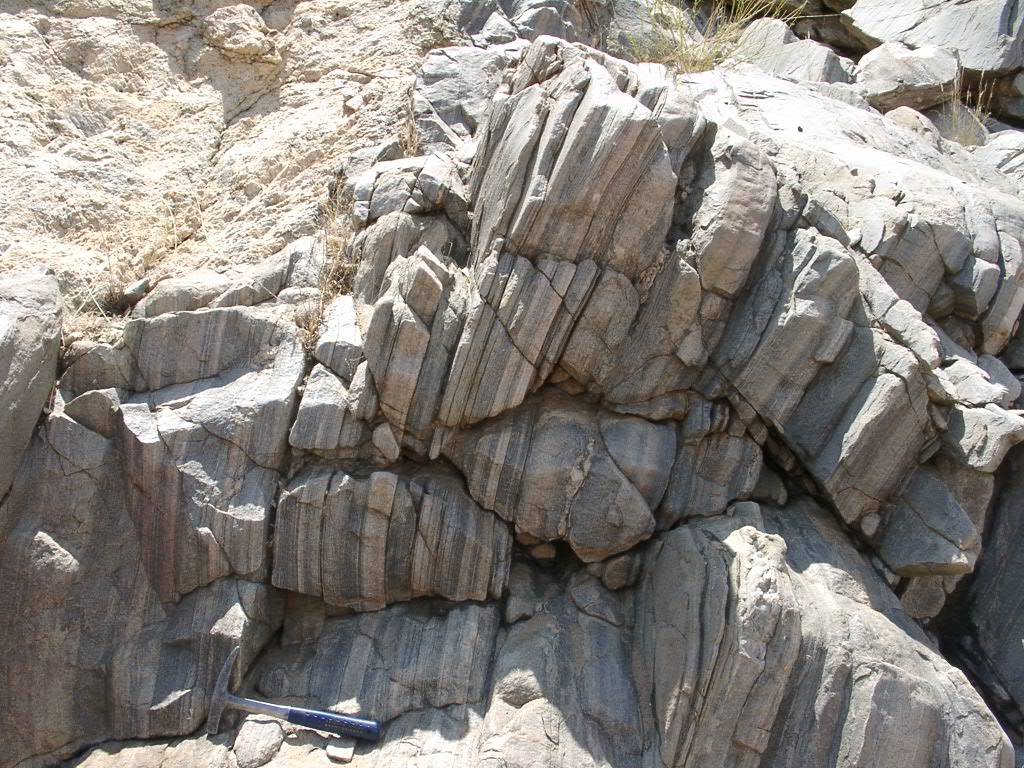
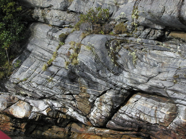
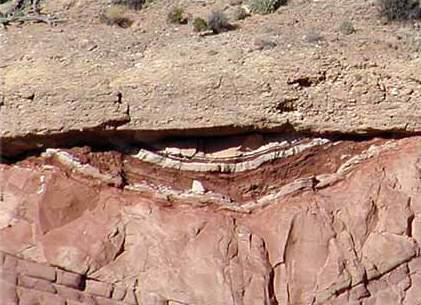
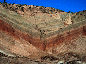
Shear zones can extend from centimeters to several kilometres in width, and display deformation, folding, and foliations in dynamically altered rocks (breccias, cataclasites, mylonites, S-L-L-S breccia or cataclasite is formed, with the rock milled and broken into a mélange of random fragments.

Pseudotachylites form at depths from 5-10 km, where confining pressures are focused into discrete fault planes and are sufficient to prevent brecciation and milling. The frictional heating at these depths can melt the rock to form pseudotachylite glass or mylonite, and adjacent to these zones, can result in growth of new mineral assemblages.

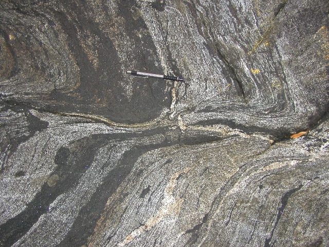
At greater depths, angular breccias transform into ductile shear textures and mylonite zones, as ductile shear zones accommodate compressive stress through dislocation creep within minerals, fracturing of minerals and regrowth of sub-grain boundaries, or by lattice glide along preferred orientation foliation planes in phyllosilicates.

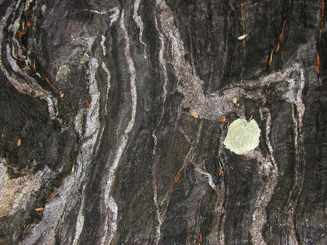
Within the depth range of 10-20km, ductile deformation conditions prevail and frictional heating is dispersed throughout shear zones, resulting in distributed deformation and a weaker thermal imprint. Here, deformation forms mylonites, with dynamothermal metamorphism observed rarely as the growth of porphyroblasts in mylonite zones.

subduction zone magmas

[links: images: animation: fabric in simple shear; shear zone experiment; 
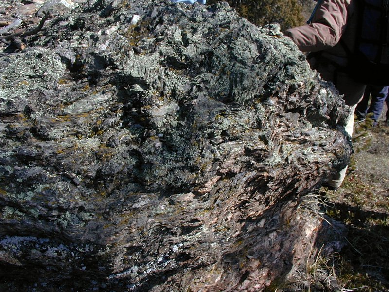
formations: mylonitic migmatitic granite-gneiss in shear zone, Epupa Complex, S of Red Drum, NW Namibia; Golden Eagle Shear Zone, Yukon; melt enhanced shear zone, along the base of an intruding batholith; shear zone in the axial zone of the Pyrenees, Parc natural del Cap de Creus, Spain; dike cutting a shear zone, Snake Range, Nevada; sheath fold in boulder, Tarfala Valley, Sweden, and sheath folds, nSweden; fold in high strain zone, NZ; close-ups: ultramylonite core (~1 cm thick) from ductile shear zone of the Diana Syenite of the NW Adirondacks; shear zone related fold in the Kohistan Arc Complex, Northern Pakistan; 
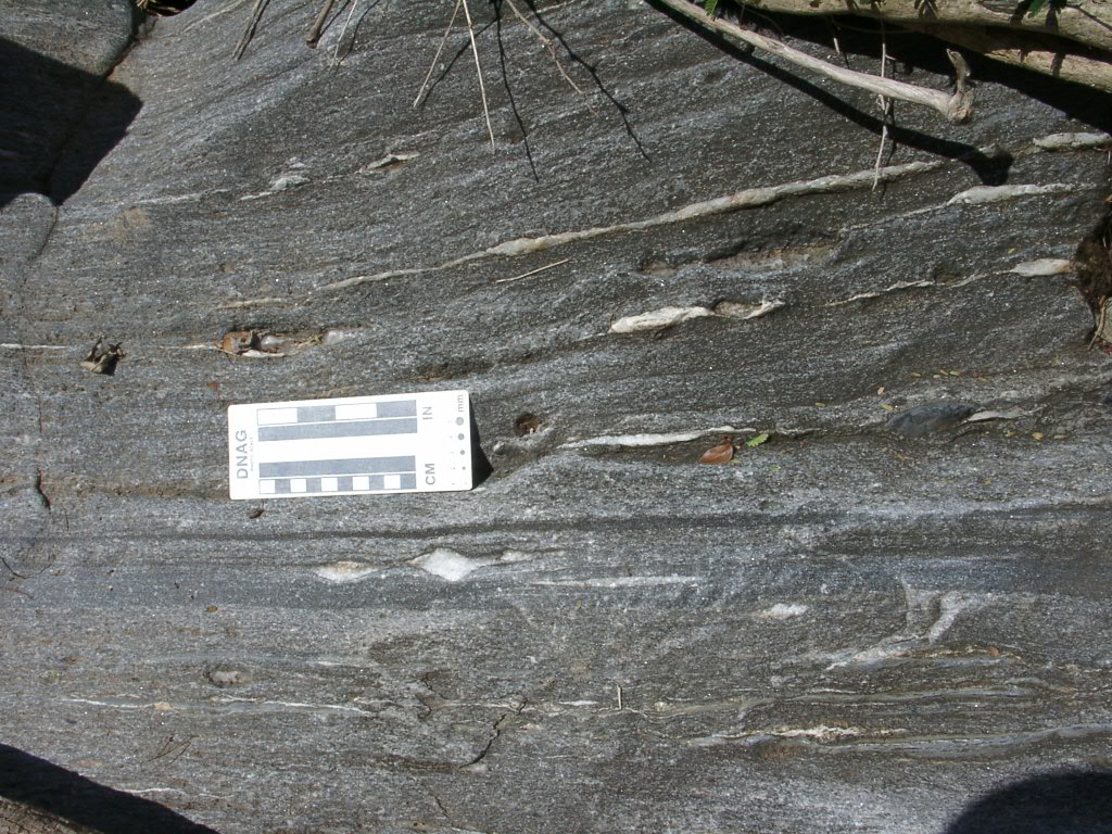
rock texture in shear zone; rock in ductile shear zone; right-lateral, ductile shear zone; anorthosite in ductile shear zone, Adirondacks; close-up of dextral shear zone; leucosome cuts gneissic layering; 1.7 Ga foliated quartz monzonite of Boulder Creek batholith in Idaho Springs-Ralston shear zone with strong mylonitic (sheared) fabric that parallels the shear zone, 2, 3; 1.7 Ga metapelite (metamorphic marine claystone) that includes large porphyroblasts of pink quartz and andalusite (dull dark gray blocky crystals), and wavy alignment of porphyroblasts in this rock with a mylonitic fabric indicates a complex deformation history; with en echelon antithetic veins in dextral shear zone, Baraboo Quartzite; sigmoidal antithetic fractures in a dextral shear zone, Tiddiline Conglomerate, Bou Azzer inlier, Morocco; mylonitic marble in shear zone, Escambray Massif, Central Cuba; lower greenschist facies shear zone cutting basement schists, assymmetric clast of pegmatite, assymmetric pod of leucogranite in schist, ptygmatic folds of leucogranite in schist, assymmetric pod of schist, Cap De Creus, neSpain; 
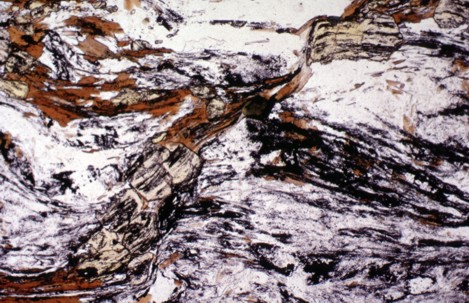
thin-sections: thin section of Lower Ordovician Pinnak Sandstone showing multiple tectonic foliations, the most prominent of which is a 
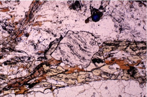
crenulation cleavage that overprints an early fine foliation; euhedral staurolite (yellow pleochroic in PPL) overgrows shear zone between large light coloured plagioclase porphyroblasts (graphite inclusions outline shear zone, staurolite crystals postkinematic); garnet with spiral-shaped inclusion trails indicating synkinematic growth, and a dextral sense of shear; diagrams: cataclasite-mylonite in shear zone; block diagram - shear zone host for gold, geometric relationships between structural elements of zone and veins; region within macroscopic shear zone illustrating bimodal porosity distribution within shear zone; model of shear zone]

Labels: , , , , , , , , , ,

sills

Sills are tabular slabs or concordant intrusive (plutonic) sheets of igneous rock that intruded laterally and horizontally, or nearly horizontally, as magma. Sills lie between and parallel to layers of older sedimentary rock, beds of volcanic lava or tuff, or along the direction of foliation in metamorphic rock.

Labels: , , , ,

slump

diagram of slumping A slump (geology) is a mass movement process of slope failure, in which a mass of rock or unconsolidated material drops along a concave slip surface. Slump units move downslope as an intact block (without internal deformation of the landslide material) and frequently rotate backwards.

Slumps appear as discrete block movements, whereas slides usually break up and travel downslope. The term 'slump' is also used to refer to the material that breaks off in a slumping slide.

(images - click to enlarge - above left, diagram of slumping; below right, slump features; bottom right, cross-section of a Toreva block.)

slump featuresSlumps are sometimes caused by clear cutting on unstable soils, and the sagging and rotational movement of the mass of soil and rock is due in part to water infiltration and lubrication of clay-rich soils below. Coastal cliffs are subject to slumping when wave action undercuts lower layers. A submarine slope slump movement may be result from tidal forces acting on an unstable slope, or from a large seismic event near the affected body of water.


Toreva block slumping is a distinctive form of landslide in which huge backrotated blocks of resistent strata such as sandstones and limestones collapsed when weaker underlying beds such as shales were undercut. cross-section of a Toreva blockThe existence of Toreva blocks suggests that an earlier warmer or wetter earlier climate existed in the region. (The Transantarctic Mountains have Toreva blocks, implying temperate conditions in Cenozoic Antarctica)


[links: fresh slumping: slumping in unconsolidated sediments, the Naze; recent slumping: Norfolk coastal slumping; slump folds in shale, Chisholm Creek, outside Wichita; slumping, 2, Milpas; old slumping: slump structures in friable sandstones of the Bournemouth Marine Beds (Eocene), channeling and slump structures, close-up of slump structures in friable sandstone, sandstone with slumps, truncated at reactivation surface; slump in cliff, Italy; slump; slump block, Clifton Creek, 2; Toreva blocks abound in the Grand Canyon area where the Bright Angel Shale has failed: two massive backrotated Toreva blocks of the Cogswell East Landslide, close-up view of the upper slide block of the East Cogswell Landslide; multiple slump blocks; Vermillion Cliffs; Surprise Valley Toreva block; webpages: 218-Mile Toreva Block; Cogswell Butte Landslides And River Diversions]

Labels: , , , ,

stock

Stocks are smaller structures than batholiths, having exposed surfaces of less than 100 sq.km..

Stocks are composite bodies that have probably been fed by deeper level batholiths and may have been feeders for volcanic eruptions. However, because considerable erosion is necessary to expose a stock or batholith, the associated volcanic rocks rarely remain.

Labels: , , ,

strata

Strata (sing. stratum) are distinctive layers or beds, of sediments or sedimentary rocks deposited consecutively, or with interruption by unconformities, atop other rocks. Each sedimentary stratum has approximately the same composition throughout, reflecting conditions at the time of deposition.

Biostratigraphy is employed to correlate the age of rocks within strata according to their fossil assemblages.

[images : Cerro de Cristo Rey, New Mexico, rock layers in the Anapra formation, 2, 3, close-up of cross-bedding; cross-bedding and flowing water; cross-lamination Pease Bay; cross-bedding Navajo Sandstone; cross-bedding Hawkesbury Sandstone; cross-bedding Kaibab; Scout Lookout; sandstone layering; cross-bedding Glenshaw Formation; slumped and deformed lacustrine sediments of Morale Claim Maar]

For a comprehensive glossary of terminology related to rock strata, see GGIPAC BeddingPattern (pdf) or html version.

Labels: , , , ,

| 0 Guide-Glossary

stress strain shear

Stress is defined as a force applied over an area, and has the dimensions F/A.

Shear is a stress that results from the opposition of forces that are not aligned (F/A).

Strain is defined as deflection divided by the original dimension, and is a measure of deformation, that is, the differential change in size, shape, or volume of a material. Strain is dimensionless.

The modulus of elasticity is stress divided by strain.

Lithostatic stress or confining pressure is uniform stress that operates equally in all directions in rocks. Confining pressure is due to the burden of overlying rock, just as seawater exerts equal pressure from all directions at depth.

Differential or divertorial stress results from compressional or extensional tectonic stresses that are not equal from all directions: tensional stress (stretching), compressional stress (squeezing), or shearing stress (side to side shearing). Compressional stresses act along the direction of maximum principal stress, whereas extensional stresses act along the direction of minimum principal stress.

For the mutually orthogonal directions along which stress is applied, the
▪ maximum principal stress direction is designated σ1 ,
▪ minimum principal stress direction is σ3 , and
▪ intermediate principal stress direction is designated σ2 .
▪ normal stress, directed perpendicular to a given plane is designated, ση
▪ shear stress, directed parallel to a given plane is designated, στ
▪ vector components of stress can be expressed according to Cartesian coordinate system as 9 components (x,y, z combinations) relative to the 3 mutually perpendicular x-y-z axes

Materials differ in their responses to stress, depending upon composition, conditions of temperature and confining pressure, and strain rate. However, regardless of intrinsic degrees of brittle or ductile qualities, all strained materials pass through 3 successive stages of deformation: elastic, ductile, and fracture (failure, or brittle deformation). Provided that the strain rate is sufficiently slow to allow minerals to accommodate structurally, minerals can adjust to applied stresses by a variety of mechanisms.

In elastic deformation, rock changes shape by a very small amount and the deformation is not permanent. Elastic deformation occurs only with small differential stresses, which are less than the rock's yield strength. Rock adjacent to failed rock in earthquakes propagates seismic waves by elastic deformation, then springs back to its original shape in elastic rebound. For this reason, structural damage to rocks and formations provides the only evidence of passage of past seismic waves.

In ductile deformation, rock deeper than 10-20 km is subjected to enormous lithostatic stress, and the high temperatures of burial render the hot rock softer and more malleable. At these depths, in the lower continental crust and mantle, rock undergoes plastic deformation and flows in response to application of a differential stress that is stronger than its yield strength. Rock undergoes ductile deformation by gradual creep along crystal grain boundaries and planes within crystal lattices. Ductile deformation in generates folding and ductile shear zone features, such the dynamic metamorphic mineralogical and textural changes seen in foliated schistose, banded, lineated, and augen-structured dynamic metamorphic rocks, mylonites, distorted porphyroclasts and mica fish, phyllonites.

In brittle deformation close to the Earth's surface, where rocks are comparatively cool, rock behaves in a brittle fashion, fracturing in response to differential stress greater than the rock's yield strength. Rock failure and fracture generates faulting, brecciation, pseudotachlites, cataclasis, and slickenside striations. Rock adjacent to the failed rock springs back to its original shape in the elastic rebound that is responsible for earthquakes.

Labels: , , , , , ,

syncline

diagram of synclineA syncline is a concave geological fold, with layers that dip downward toward the center of the structure. This arrangement is opposite to that of an arching anticline.

Provided that the syncline has not been overturned, strata within synclines have progressively younger rock layers toward the center of the syncline, with the youngest layer at the fold's center or hinge, mirrored by the same layers in reverse sequence on the opposite side of the hinge. Elongate circular or circular fold patterns create basin structures.

syncline, courtesy of USGSFolding typically develops during crustal deformation as the result of compression that accompanies orogenic mountain building.

Strata folded as the Rocky Mountains formed. Near Mount Withrow in northeastern B.C., a prominent syncline is outlined by beds of sandstone that form ridges because they are resistant to weathering. A low area at the centre of the fold is underlain by shale, which weathers very readily. The syncline stretches off into the distance.

Wyoming's Powder River Basin is another notable example of synclinal folding.


[ links: images: formations: synclinal folds outlined by ridges of resistant sandstone, Rocky Mountains near Mt. Withrow; syncline core in Miocene sandstone and shale from the western Tarim Basin, China; Syncline near Indus Suture, Tibet; syncline and unconformity; Mojave syncline that formed at a bend in a strike-slip fault in Rainbow Basin, 2, aka Barstow syncline; Mexican Hat Syncline, UT; overturned syncline in Taconic slates, VT; Scotch Hill syncline, VT; synclinal; sycline in Lockhart Basin, UT; 3D Camargo syncline in central Bolivia (3D glasses needed); Camargo syncline, 2; Camargo syncline center foreground and the San Juan de Oro surface unconformably over it in the background, view looking south with LandSat image draped over the topography; syncline exposed in Monarch Canyon in the Funeral Mountains, Death Valley; Tremont syncline in Llewellyn Formation, PA, Alleghanian Orogeny 290-250Ma; syncline and some accommodation structures near Bude, Cornwall; The Glen Lake Syncline; anticline and syncline and complicated folds near Calico Ghost Town, Yermo, California; Sideling Hill, western Washington County, Maryland Syncline; syncline in Maryland I-68 roadcut, 2, 3, 4, 5; anticline-syncline pair, Canadian Rockies; Gibson Peak syncline; tightly folded syncline that formed as a drag fold along the boundary of a thick, Miocene, andesite dike (upper left), Monterey Shale at Crescent Bay in Laguna Beach; Monument Fold, Colorado River; syncline, 2; satellite: Tindouf syncline; plunging anticlines and synclines, Dinosaur National Monument, UT; monocline and syncline; Henry Mt. laccoliths, Capitol Reef, UT; monocline and syncline crossed by transverse stream, Capitol Reef, UT; Atenango Del Rio Syncline, pseudo false color, false color composite, principle components, digital elevation model; diagram: fold types; websites: Fault Block Mountains Folded Mountains Upwarped Mountains Accreted Mountains; Geology of the Sideling Hill Road Cut; Camargo Syncline Geology]


Labels: , , , , , , , , , , , ,

. . . evolving since 01/07/07