Geology
Definitions and images to illustrate geological terms, links to images and website articles
laccoliths
Laccoliths are moderately large concordant intrusions that cause uplift and folding of the preexisting, country rocks above the intrusion. Laccoliths tend to form at relatively shallow depths beneath relative light sedimentary rocks, ensuring that the pressure of intruding magma is sufficiently high to lift overlying rock strata, forming a domed or mushroom-like form with a generally planar base. Laccoliths typically arise from relatively viscous magmas, such as those that crystallize to diorite, granodiorite, and granite.
[images laccolith, 2, 3, 4, 5; laccolith (l) and set of sills (r); monocline and syncline; Henry Mt. laccoliths, Capitol Reef, UT, anaglyphic images (needs 3D glasses); Mt Hillers, Sawtooth Ridge; Mt Ellesworth, UT; DEM Black Mesa laccolith; diagram laccolith Black Hills, SD; Bear Butte, SD, photo; Mt. Elden laccolith; Los Cuernos; topo map of Mount Katahdin laccolith]

[images laccolith, 2, 3, 4, 5; laccolith (l) and set of sills (r); monocline and syncline; Henry Mt. laccoliths, Capitol Reef, UT, anaglyphic images (needs 3D glasses); Mt Hillers, Sawtooth Ridge; Mt Ellesworth, UT; DEM Black Mesa laccolith; diagram laccolith Black Hills, SD; Bear Butte, SD, photo; Mt. Elden laccolith; Los Cuernos; topo map of Mount Katahdin laccolith]
Labels: concordant, country rock, diorite, faulting, Granite, granodiorite, intrusion, laccolith, uplift
Laurentia
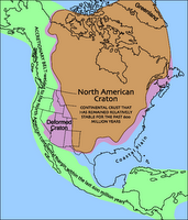
 Laurentia, or the Laurentian Shield, or the Canadian Shield is the geological term for the North American Craton.
The North American Craton (brown) has comprised a portion of a series of supercontinents, and has remained stable for about 600 million years. This cratonic region comprises a basement of Precambrian metamorphic and igneous rock, exposed in the north as the Canadian Shield, and covered by a relatively thin cover of younger sedimentary rock on the Interior Platform.
The geologically stable rocks of the cratonic core are surrounded by deformed rocks (purple) and more recently deposited sedimentary material (green). Compare to bedrock of North America.
Maps of North American rock types : rock types - metamorphic, plutonic, sedimentary, volcanic; tapestry of time and terrain, terrain.
Labels: basement, Canadian Shield, Interior platform, Laurentia, Laurentian Shield, North American craton, Precambrian basement rock, supercontinets
| 0 Guide-Glossarylopolith
Lopoliths are saucer shaped concordant emplacements that lie parallel to the strata of intruded country rock.
Lopoliths are relatively small plutons that typically developed an upper surface that is concave downward. This sagging shape may be attributable to volume reduction when magmas crystallize. The weight of the overlying strata would cause collapse into the volume previously occupied by more voluminous liquid magma.
Lopoliths formed by a similar mechanism to laccoliths, but they are composed of dense, mafic magma that allows depression by the overlying strata on cooling. Many lopoliths contain layered gabbroic rocks. Some lopoliths are very large, with thicknesses of many kilometres. The Bushveldt lopolith in southern Africa is several hundred kilometres across and contains the richest platinum deposits known.
image Bushveldt volcanics
Labels: Bushveldt lopolith, lopoliths, platinum deposits


